Monday, July 19, 2010

Mirror Lake Run.


I tried out a few new things today including a training run up in the Unitas. I'll start by talking about the 'new and cool tech stuff' and then talk about the route.

First off, I'm not sure if you have noticed, but a new(ish) electrolyte drink powder is out called EFS. http://www.firstendurance.com/ The two stores I went to both told me this was THE stuff, everyone was buying it, get your hands on it before its all gone, so of course I bought one. In comparing your 4 major electrolytes, EFS has significantly more than anyone else, not to mention you get more servings per contain, AND the container is actually the right size, not like a GU container which you open and its already half empty. Based on a 12 ounce serving EFS has 1160mg of electrolytes(Na, Ca Mg, CL K+) compared to

Hammer at 162mg
Cytomax at 200mg
GU 216mg
Gatorade Endurance 435mg

I might mention that it doesn't mention the Hammer as Hammer endurance, but this would probably make a difference. EFS then has over 2 times the amount at Gatorade, and 5 times more than most everyone else. Good or bad? I think it depends on a lot of things. How hot it is, how much YOU sweat would be the primary questions. EFS also has an Amino Acid content of 2000mg.

So I've used EFS on two runs now, the first was about 9 miles 7500ft to about 9800ft and after following the instructions and adding 1 scoop to 12 ounces of water, I made it about 1/3 into the run and I couldn't drink the stuff anymore (which was in all 4 water bottles, shesh amateur) And because of it I could feel myself dehydrating rapidly(like the top of your mouth starts to get dry), but it was also causing a chemical imbalance that was going to make me upchuck. After reaching the next water source I just pored the remaining out and took some fresh water with Iodine, and chugged. Back in business. The second run I took with EFS I cut the recommended portion down to 1/3-1/4 the recommend serving and things went much better, but STILL it was difficult to stomach. Obviously the high levels of Sodium are part of the problem but I also wonder if its the 2000mg of Amino Acids that I'm not stomaching well? I don't know but after 4 bottles or just under 4 servings I was done for the rest of the day and stuck with water (and Iodine) and Hammer Electrolyte Pills. This seems to work pretty well but I had this funk taste left in my mouth that made the water almost bitter, and I'm not sure if it was from the iodine (which isn't new to my mouth) or the EFS. I never really got over it. Its actually reminded me of the smell (weird I know) of a Diabetic when they start metabolizing fat after their glucose has run out. So I'm not sure how much I like this stuff, unfortunately I've got $25 worth of it left so I better keep trying. The good thing is that I also have a new tech Suunto Vector http://www.ems.com/product/index.jsp?productId=3661486 want-a-be watch from high gear that has a hydration alarm to keep me on task.

This new watch does everything that the vector does plus a little, and minus a little. The cool part is you can set the Altimeter with either the actual altitude or by Sea Level Pressure, very cool. The Vector cant do that. The Problem I have with it is the compose calibration has failed EVERY time, I've tried multiple times at home and 3-4 times on the trail today. So you don't have to carry a compose, as long as you trust the uncalibrated one. That being said it was very accurate when put up against the Topo. The down side is that when your recording an activity 1.) The altitude doesn't have close enough measuring intervals, and 2.)sometimes you accidental press the stop button by bending your wrist to the wrong position. This happened today 2 times. The first time I didn't notice for a long, long time. So because of this my times are pretty off.

One more rant, then I'll give you the route. I have a polar F11 heart rate monitor http://www.heartmonitors.com/polar/polar_f11_heart_rate_monitors.htm that I really love, but the ONLY way to change the batter is to send it back to polar! That's fine if you only use it once every 2 weeks, but if you are using it 3-5 times a week, you don't have the time. And don't try and do it yourself, there is a reason the have you send it in. I changed the battery last year, and I almost killed it forever.

The route, Finally. Parenthesis show Forest Service route numbers. I started at Mirror lake trail head and headed South (086) down the Duchesne River to the East Fork river confluence where I then turned North East (087) and headed up to Pinto Lake via the Skinner's cut off trail, the South to Governor Dern Lake, and Rainbow lake. Here I Planned to turn north (074) towards 4 lakes basin, but instead missed the sign and ran half way or more to Lost Lake where I finally realized it and backtracked to Rainbow Lake again. Then up to Bedground Lake then straight North (085) to Olga Lake to meet the Rocky Sea Pass Trail(083). Left turn (WNW) at the T on Highline Trail all the way back to Mirror lake.

Sound easy right? Well with the detour, its between about 24-27 miles, 2700ft of climbing and descending, and a very rocky and technical trail. My fancy watch clocked in at 5 hours 48 minutes but I'm sure it was more like 6hours 30 minutes due to the off time. That seems ridiculously slow, but the more I think about it, I'm not sure you could go much faster. 50% of the trail is very technical rocks, logs, marshes, and ball bearings, and the other 50% is still rocky and steep. Even if you had the lungs to run a 9 minute mile above 10K I'm pretty sure you'd make it about 20 feet before twisting your ankle and breaking your jaw (when your face impacts one of the big rocks in front of you). I'm sure you could cut off an hour or two if your name was Dean Karnazes http://www.ultramarathonman.com/flash/

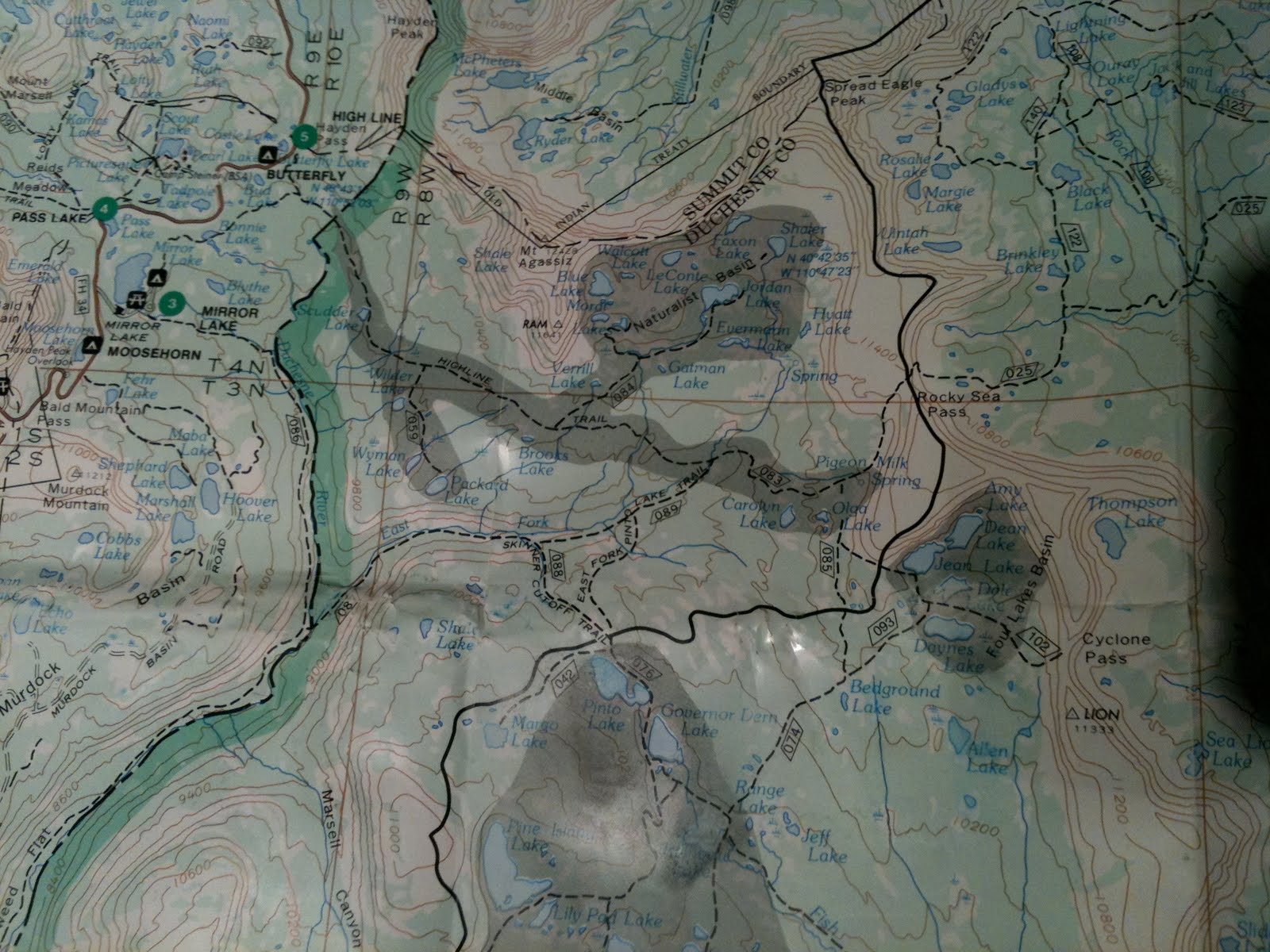
It is a beautiful route, with plenty of water sources, and very few people. I would recommend it. I couldn't fit the camera in my tiny water belt so I can't share any of the magnificent images with you, next time. Just bring everything you need because there are no 7-11's on the way and a twisted ankle is very likely!

Monday, July 12, 2010

To WURL or not to WURL


So I've been thinking about the WURL a lot laterly. First because Jared did it on skies (WURLOS) and because it seem like an excellent training tool for the W100. WURL stands for Wasatch Ultimate Ridge Link Up. I haven't really done my research on it like I should, but basically you start somewhere either in Ferguson or Broads and climb to Twin Peaks then hit them all to Twin Lakes Pass, then you turn South to Alta and then Turn West again and hit them all to lone peak and exit out Bells. Its doesn't seem to be set in stone the course, but that's the basic idea. I had two days off left of my vacation so I figured I'd go up and try it out and see if its plausible for someone like me. So I packed up a small pack with enough goodies for 2 days out (2 days of suffering, not comfort) with just a few items.

I planned on leaving at 300am, but by the time I was packed it was midnight so I set the alarm for 400am. All in all I started hiking at 5:38am, probably 30 minutes to an hour too late, but I didn't expect to finish the whole thing in one day.

After taking a different route to the summit of Twin(11330), it was about 3 hours in, 1 hour later than I had hoped. A short photo and I was off.
Twin I might add is a bit of a rip off because you have to summit both peaks and it takes a good 20-30 minutes to hit them both, but you only get one.


I also got the peak north of twin(10800), at the top of Stairs Gulch. Then moving on to Sunrise (11275) their was one extra(11200) in between and some serious scrambling. Sunrise has some full on climbing I would give about a 5.4 with some lose rocks and ending in a choss pile (like every other peak). It turned out to be not too bad except the exposure, and the running shoes. Then moving down Sunrise turned out to be the biggest thrill of the day as it was extremely difficult to transition through the saddle to Dromedary. In retrospect I could have chosen a better line but I'd give it down climbing 5.7 with lose rocks and dirt EVERYWHERE.

A short moment to describe the traveling. Its like taking 1000 granite tiles and stacking them on top of a low pitch roof, on top of the Sears Tower. This is about the consistency of the rock on all of these peaks with short burst of good stuff. So you move agonizingly slow, and carefully place every foot and hand most of the time. A slide could be fatal a good portion of the time. I would describe this as having a 'high objective hazard' or a hazard that you can't do anything about. I do have time climbing choss piles, but not piles of it, so this was pretty stressful for me.

After the summit of Dromedary I got sucked into a trail that led down towards Lake Blanch. Turns out it was the wrong trail so I ended up crossing a Quartzite slab, that also happened to be the run off from remaining snow. Another very stressful moment. then going around to the decent side I reach the knife edge ridge, choss pile. Similar to the one on the Pfeiffer, but longer, chossier, and maybe even higher off the deck. After a moment of thinking I decided I'd had enough and the payoff wasn't worth taking yet another risk crossing this ridge. If I came off with a boulder it would mean serious injury, or more likely death.

I don't mind crossing some sections like this, but when you've been doing it for the last 3 hours the risk becomes too much. I decide then that I wouldn't come back to the WURL, because of the high danger associated with this first section. As time has pasted it seems less and less, so who knows I might come back. I'm not sure what the answer is, but it seems like a rope would be too big of a burden. Maybe climbing shoes and a partner, I don't have an answer. Either way the risk is pretty big on this one. I would much rather take a 40 foot wipper than fall off of one of those things.

I down climbed from Dromedary on the trail I noticed down to Blanch lake and at first was thinking about heading back up on far lookers left of Mill B South to the back side of the saddle between Superior and Monte Cristo. Not a bad plan, until you figure out how high above the lake you really are.


I would estimate it took me 2-3 hours to get from Dromedary to Lake Blanch, even with a sick section of Glissading.

Again the down climb was difficult and very slow, but reasonably safe. Then climbing back up would take a while to because of the brush, rivers and indirect route. I was at hour 9 by now and decide to just bail because I was so far behind where I should be.

If you where on ski's, I think this would be the choice because it would only take 10 minutes down and maybe 1 hour back up.

All in all car to car time was 10 hours with 5 peaks, all over 11000ft and about 7000ft of vertical and somewhere in the range of 8 or 9 miles. As of now, its not to WURL