Showing posts with label Trail Running. Show all posts

Wednesday, July 27, 2011

S.A. Ridge, Benchmark set.


One of the first runs of the season with my trusty running partner was up to Grandeur Peak where we noticed a beautiful ridge to the North that we hadn't ran before. As always happens on one adventure, another was formed.

Of course I wasn't going to do any research, but my motivated friend set out a course on google maps (or some more tech version) that showed the route. He even had a three dimensional track we fly by to have a look. It looked easy. About 8 miles of rolling terrain with a big decent at the end. We did a trial run shortly after that covered about the first 4 miles. It went very well, except it wasn't rolling terrain. The hills where big, and more importantly steep. At least big hills are great for training.

The highest altitude on the route is about 7500ft and it descends to 4800ft. Because of the low altitude, its more of a spring, fall, winter type route. Naturally, I decide to give it ago at 5:00pm at the end of July. After smoking through the first 4 miles I get to the new terrain (by smoking I mean slightly faster than walking). I'm expecting a short easy ridge to a big rocky decent. I was dead wrong. Had my wife been along she would have said something wise like: 'maybe we should turn arround' or 'that doesn't look too fun up ahead.' Unfortunately I was all alone and the thought of return never even crossed my mind. I jumped headlong into the Oak brush. As always I was wearing skimpy running shorts and a super light water wicking shirt. As you can imagine, the bush whacking didn't go so well.
I think I had about 1.5 miles of no trail on a steep almost knife edge ridge that was covered in thick, deep oak brush. I think I would label this section the meat grinder. for the first 30 minutes I found it very amusing how difficult it was to move at all through the brush. I was literally dragging myself through in sections. To add to the fun, at times you would come to a huge sandstone boulder that you got to climb over (don't ever say we don't have Sandstone in northern Utah). After an hour and a half it finally started to clear up. ( yeas thats 1.5 miles in 1.5 hours) My legs where bleeding, my shoes where filled with rocks, and I was in a fowl mood.
Just then my wife called to let me know she was still at work and it was ok that I was way, way late. Of course I complained about how much I was suffering (really? like when you get to work 40 hours a week?) and she generously showed much sympathy. From here the trail got really, really good. In fact, I would give this section a 3 star trail, and its accessible from my house! My mood rapidly improved, and as always within 20-30 minutes the bush whack from hell faded into darkness. I'll try and attach a movie or two this time which explains a little of how I was feeling at the time. You can see the bush whack section in the photo's with the sand stone boulder sections... see if you can find the trail of blood and broken branches. I think I am going to upgrade it from a no star run to a one star run.Stats:
Route: starting at the parking lot at the top of little mountain, finishing at the foothill clinic
Time: 3:04:13
Distance: 7.72 miles
Pace: 23:51
Starting Elevation: about 6,000ft
Ending Elevation: 4,800ft

This is your challenge to break my record, just bring your Levis.

Monday, July 19, 2010

Mirror Lake Run.


I tried out a few new things today including a training run up in the Unitas. I'll start by talking about the 'new and cool tech stuff' and then talk about the route.

First off, I'm not sure if you have noticed, but a new(ish) electrolyte drink powder is out called EFS. http://www.firstendurance.com/ The two stores I went to both told me this was THE stuff, everyone was buying it, get your hands on it before its all gone, so of course I bought one. In comparing your 4 major electrolytes, EFS has significantly more than anyone else, not to mention you get more servings per contain, AND the container is actually the right size, not like a GU container which you open and its already half empty. Based on a 12 ounce serving EFS has 1160mg of electrolytes(Na, Ca Mg, CL K+) compared to

Hammer at 162mg
Cytomax at 200mg
GU 216mg
Gatorade Endurance 435mg

I might mention that it doesn't mention the Hammer as Hammer endurance, but this would probably make a difference. EFS then has over 2 times the amount at Gatorade, and 5 times more than most everyone else. Good or bad? I think it depends on a lot of things. How hot it is, how much YOU sweat would be the primary questions. EFS also has an Amino Acid content of 2000mg.

So I've used EFS on two runs now, the first was about 9 miles 7500ft to about 9800ft and after following the instructions and adding 1 scoop to 12 ounces of water, I made it about 1/3 into the run and I couldn't drink the stuff anymore (which was in all 4 water bottles, shesh amateur) And because of it I could feel myself dehydrating rapidly(like the top of your mouth starts to get dry), but it was also causing a chemical imbalance that was going to make me upchuck. After reaching the next water source I just pored the remaining out and took some fresh water with Iodine, and chugged. Back in business. The second run I took with EFS I cut the recommended portion down to 1/3-1/4 the recommend serving and things went much better, but STILL it was difficult to stomach. Obviously the high levels of Sodium are part of the problem but I also wonder if its the 2000mg of Amino Acids that I'm not stomaching well? I don't know but after 4 bottles or just under 4 servings I was done for the rest of the day and stuck with water (and Iodine) and Hammer Electrolyte Pills. This seems to work pretty well but I had this funk taste left in my mouth that made the water almost bitter, and I'm not sure if it was from the iodine (which isn't new to my mouth) or the EFS. I never really got over it. Its actually reminded me of the smell (weird I know) of a Diabetic when they start metabolizing fat after their glucose has run out. So I'm not sure how much I like this stuff, unfortunately I've got $25 worth of it left so I better keep trying. The good thing is that I also have a new tech Suunto Vector http://www.ems.com/product/index.jsp?productId=3661486 want-a-be watch from high gear that has a hydration alarm to keep me on task.

This new watch does everything that the vector does plus a little, and minus a little. The cool part is you can set the Altimeter with either the actual altitude or by Sea Level Pressure, very cool. The Vector cant do that. The Problem I have with it is the compose calibration has failed EVERY time, I've tried multiple times at home and 3-4 times on the trail today. So you don't have to carry a compose, as long as you trust the uncalibrated one. That being said it was very accurate when put up against the Topo. The down side is that when your recording an activity 1.) The altitude doesn't have close enough measuring intervals, and 2.)sometimes you accidental press the stop button by bending your wrist to the wrong position. This happened today 2 times. The first time I didn't notice for a long, long time. So because of this my times are pretty off.

One more rant, then I'll give you the route. I have a polar F11 heart rate monitor http://www.heartmonitors.com/polar/polar_f11_heart_rate_monitors.htm that I really love, but the ONLY way to change the batter is to send it back to polar! That's fine if you only use it once every 2 weeks, but if you are using it 3-5 times a week, you don't have the time. And don't try and do it yourself, there is a reason the have you send it in. I changed the battery last year, and I almost killed it forever.

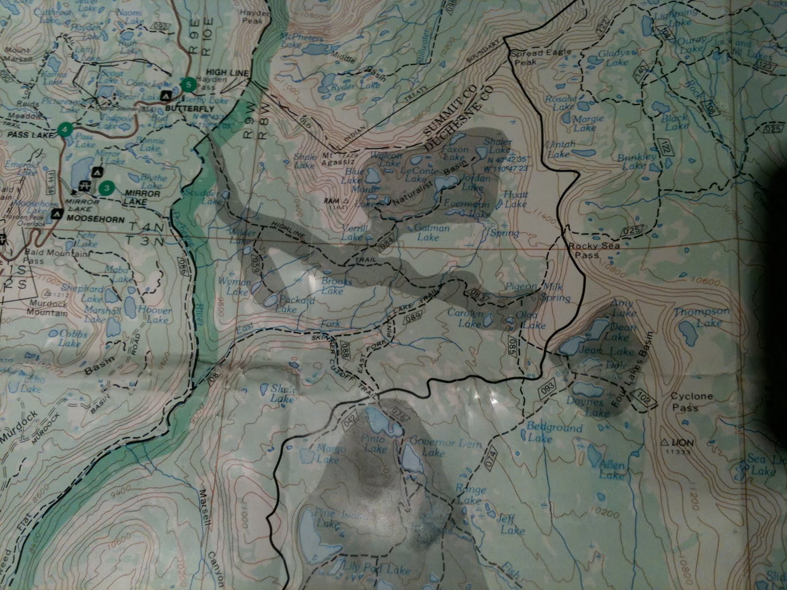
The route, Finally. Parenthesis show Forest Service route numbers. I started at Mirror lake trail head and headed South (086) down the Duchesne River to the East Fork river confluence where I then turned North East (087) and headed up to Pinto Lake via the Skinner's cut off trail, the South to Governor Dern Lake, and Rainbow lake. Here I Planned to turn north (074) towards 4 lakes basin, but instead missed the sign and ran half way or more to Lost Lake where I finally realized it and backtracked to Rainbow Lake again. Then up to Bedground Lake then straight North (085) to Olga Lake to meet the Rocky Sea Pass Trail(083). Left turn (WNW) at the T on Highline Trail all the way back to Mirror lake.

Sound easy right? Well with the detour, its between about 24-27 miles, 2700ft of climbing and descending, and a very rocky and technical trail. My fancy watch clocked in at 5 hours 48 minutes but I'm sure it was more like 6hours 30 minutes due to the off time. That seems ridiculously slow, but the more I think about it, I'm not sure you could go much faster. 50% of the trail is very technical rocks, logs, marshes, and ball bearings, and the other 50% is still rocky and steep. Even if you had the lungs to run a 9 minute mile above 10K I'm pretty sure you'd make it about 20 feet before twisting your ankle and breaking your jaw (when your face impacts one of the big rocks in front of you). I'm sure you could cut off an hour or two if your name was Dean Karnazes http://www.ultramarathonman.com/flash/

It is a beautiful route, with plenty of water sources, and very few people. I would recommend it. I couldn't fit the camera in my tiny water belt so I can't share any of the magnificent images with you, next time. Just bring everything you need because there are no 7-11's on the way and a twisted ankle is very likely!